At a glance
Map
Data sources
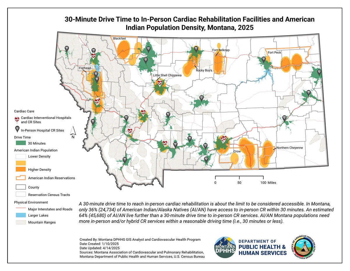
This map displays 30-minute drive time service areas around in-person cardiac rehabilitation facilities and interventional hospitals in 2025. The map denotes drive time service areas in green polygon boundaries with point features for the CR facilities.
Montana has seven reservation areas. Those jurisdictions are designated with an orange outline boundary. A layer for population density (2020) of American Indian/Alaska Natives (AI/AN) is included, ranging from light to darker orange, depicting higher population density with increasing darkness of orange. At the bottom of the map is a note stating, "A 30-minute drive time to reach in-person cardiac rehabilitation is about the limit to be considered accessible. In Montana, only 36% (24,734) of AI/AN have access to in-person CR within 30 minutes. An estimated 64% (45,680) of AI/AN live further than a 30-minute drive time to in-person CR services.
AI/AN Montana populations need more in-person and/or hybrid CR services within a reasonable driving time (i.e., 30 minutes or less)." Only the Flathead reservation has CR facilities accessible on their reservation.
ArcGIS Pro 3.4.0
Health care locations; program services; U.S. Census; Tigerline 2020 Block Groups, Tigerline 2020 Tracts, American Community Survey.
Montana in-person cardiac rehabilitation program locations were geocoded. A 30-minute drive time service area was drawn in green around each facility location. This data was overlaid with other data such as a kernel density layer representing American Indian Alaska Native population density. Darker orange color indicates higher density.
This map will be presented as part of the Montana Cardiovascular Health Program and Office of American Indian Health activities. The map allows Montana Department of Public Health and Human Services staff to engage in discussions with tribal leaders, interventional hospitals, and cardiac rehabilitation (CR) facilities to create new options for hybrid or home-based CR services for reservation communities.
Brian Norderud, Geographic Information Systems Analyst
Montana Department of Public Health and Human Services
406-444-7896
brian.norderud@mt.gov
Brian Norderud, Geographic Information Systems Analyst, Montana Department of Public Health and Human Services. Accessed from the Centers for Disease Control and Prevention's Chronic Disease Map Gallery.