At a glance
Map

Data sources
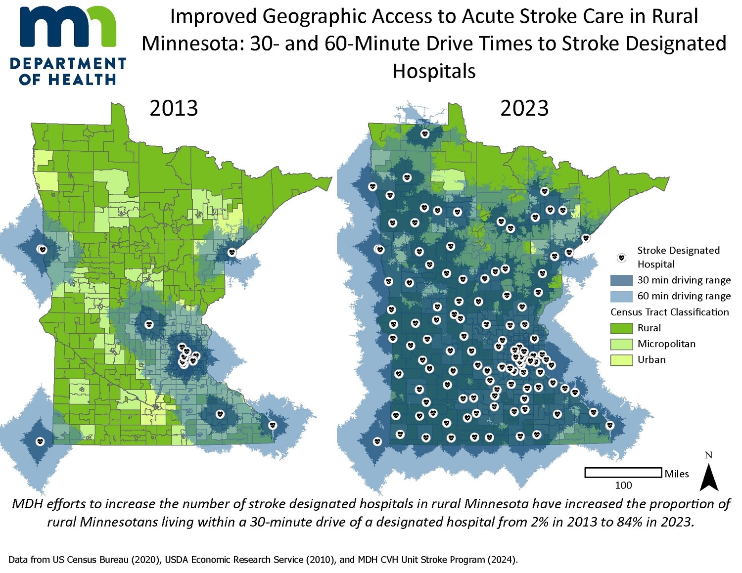
This map displays census tract rurality (rural, micropolitan, and urban) for the state of Minnesota along with locations of stroke designated hospitals in 2013 and 2023. 30- and 60-minute drive time ranges for stroke designated hospitals are displayed to illustrate the increase in rural areas with timely access to stroke care in designated hospitals in 2023 compared to 2013. Additionally, the map text explains that the proportion of rural residents within these 30 and 60 minute driving ranges has increased from 2% in 2013 to 84% in 2023.
ArcGIS Pro
Health Care Settings; U.S. Census; MDH CVH Unit Stroke Program Data on Stroke Designated Hospitals; USDA Economic Research Service Rural-Urban Commuting Areas data.
Locations of stroke designated hospitals (including Acute Stroke Ready Hospitals, Primary Stroke Centers, and Comprehensive Stroke Centers) were drawn from MDH Stroke Program data and mapped by coordinates. Census tract rurality was mapped using USDA Rural-Urban Commuting Areas data, with census tracts with primary RUCA codes 1-3 coded as "Urban"; 4-6 coded as "Micropolitan" and 7-10 coded as "Rural". Drive times to designated hospitals were calculated using ArcGIS Pro network analysis tool for 30 and 60 minute drive times towards designated facilities. Centers of Population from the US Census Bureau for 2010 and 2020 and ArcGIS Pro intersections by location tool were used to calculate the proportion of residents in rural areas within 30 minutes of designated hospitals.
This map has been used internally to document the impacts of stroke designation in rural Minnesota and will be shared with a variety of partners and audiences through program presentations, conference posters, and newsletter updates.
Mimi Amelang, Evaluation Specialist
Minnesota Department of Health
651-201-5627
Mimi.amelang@state.mn.us
Mimi Amelang, Evaluation Specialist, Minnesota Department of Health. Accessed from the Centers for Disease Control and Prevention's Chronic Disease Map Gallery.
