Key points
Map

Data sources
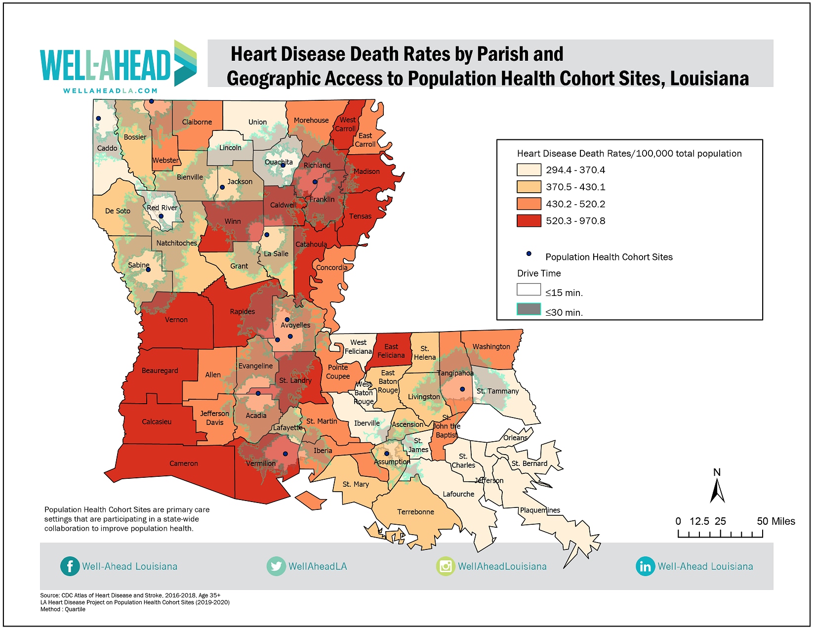
This map highlights geographic disparities in health status among Louisiana residents which reflects chronic conditions and poor health outcomes. The heart disease death rates are higher in the south- west and north- east regions of the state with highest rate of 970.8/100,000 populations in Franklin county followed by Caldwell (720.2) and Madison (686.3) respectively. Healthcare access and outcomes vary enormously across Louisiana from one community to another. The Population Health Cohort Sites are mainly concentrated in the northern and central part of Louisiana. Most cohort sites do not reside in parishes with highest heart disease death rates, suggesting limited access to these collaborative improvements in population health for these high risk populations.
ArcGIS Pro
Heart Disease death rates (CDC Atlas of Heart Disease and Stroke)
Louisiana Heart Disease Project on Population Health Cohort Sites (2019-2020)
A choropleth map of heart disease death rates was created with categories defined as quartiles. Geocoding process was used to map the Population Health Cohort sites using ArcGIS Pro Composite. We investigated geographical accessibility around Population Health Cohort sites. Geographic accessibility was calculated by identifying the number of people residing within fifteen and thirty-minute drive times of the Population Health Cohort sites through network analysis. Map was created using ArcGIS Pro (2.5.0).
The Population Health Cohort in Louisiana is a collaborative quality improvement opportunity. This map will support the implementation of strategies aimed at improving population health within a primary care setting and facilitate in implementing evidence-based practices that can improve their quality of care and their health metrics. This map will enhance partnerships and the need for further improvement in addressing disparities.
Alok Bhoi, Epidemiologist
Well-Ahead Louisiana
alok.bhoi@la.gov
Bhoi, Alok, Well-Ahead Louisiana. Accessed from the Centers for Disease Control and Prevention's Chronic Disease Map Gallery.
