At a glance
Map

Data sources
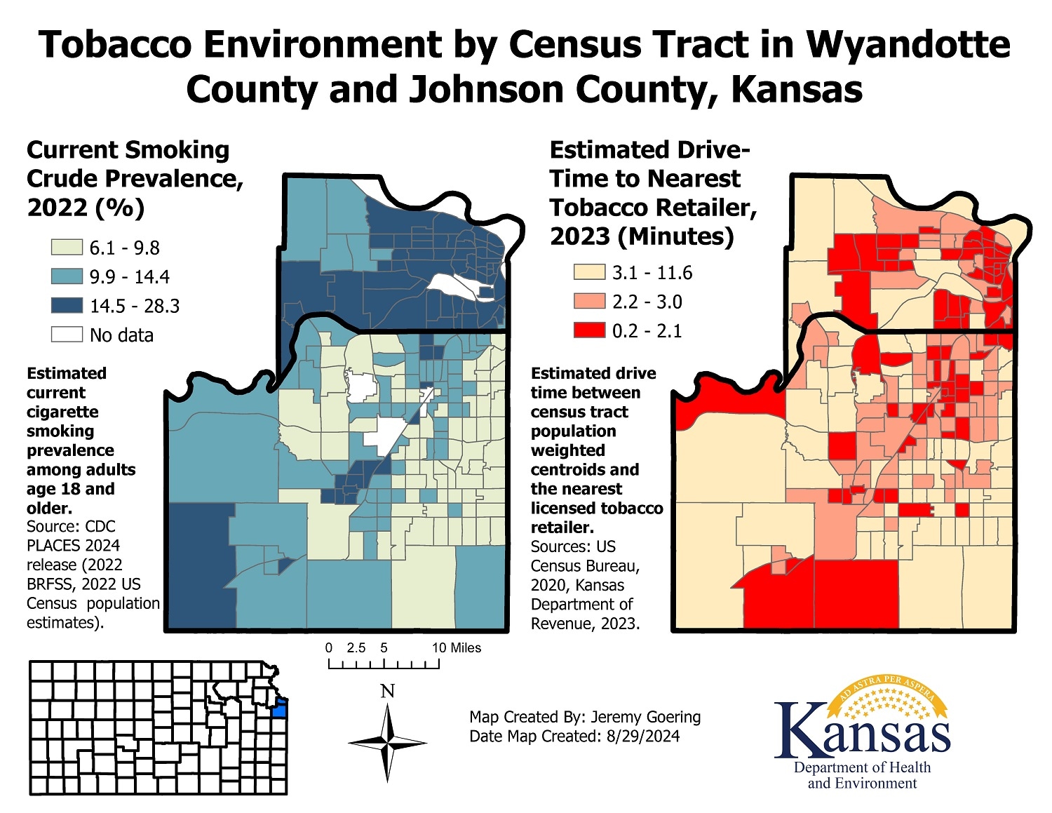
This map displays two census tract-level choropleth maps of the tobacco environment in Johnson County and Wyandotte County, Kansas. The first map displays crude prevalence of current cigarette smoking among adults age 18 or older, by census tract, for the year 2022. In this choropleth map, census tracts are shaded according to drive-the smoking prevalence tertile they belong to. Compared to Johnson County, Wyandotte county has a higher proportion of census tracts belonging to the highest tertile of cigarette smoking prevalence.
The second map displays the estimated drive-time, in minutes, between the census tract population-weighted centroid and the licensed tobacco retailer nearest to that centroid for the year 2023. In this choropleth map, census tracts are shaded according to the drive-time tertile they belong to. Compared to Johnson County, Wyandotte County has a higher proportion of census tracts where the drive time from the center of population is the lowest tertile, indicating a short drive-time to a tobacco retailer.
ArcGIS Pro
BRFSS/PLACES; U.S. Census; Centers of Population, US Census Bureau, 2020.
Census tract-level map of crude smoking prevalence generated with ArcGIS pro software, using data from CDC PLACES 2024 release. This release of PLACES utilizes data from 2022 Behavioral Risk Factor Surveillance System (BRFSS) and US Census 2022 population estimates to generate census-tract level estimates of current cigarette crude smoking prevalence among adults age 18 and older. Drive-time analysis was performed using Closest Facility Network Analysis tools within ArcGIS Pro software. Drive-time (in minutes) reflects the estimated drive time between each census tract population weighted centroid (US Census Bureau, 2020) and the licensed tobacco retailer (Kansas Department of Revenue, 2023) that is nearest to that centroid.
This map will be used by the Kansas Department of Health and Environment (KDHE) Tobacco Use Prevention Program (TUPP) to document the burden of tobacco and inform program planning. It will be shared with local partners, such as Chronic Disease Risk Reduction (CDRR) grantees and other local partners to inform their programs and policy work surrounding tobacco prevention and cessation.
Additionally, the GIS tools and principles used to create this map will be used for similar analyses in other regions of the state, and for other topics related to chronic disease prevention.
Jeremy Goering, Epidemiologist
Kansas Department of Health and Environment
316-213-9305
jeremy.goering@ks.gov
Jeremy Goering, Epidemiologist, Kansas Department of Health and Environment. Accessed from the Centers for Disease Control and Prevention's Chronic Disease Map Gallery.
