Key points
Data sources
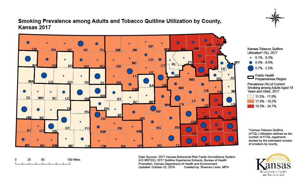
The highest prevalences of current smoking among adults aged 18 years and older in 2017 are located in the Northeast and Southeast regions of the state. These regions also have some of the highest KTQL utilization rates in the state (0.7% – 1.2%). The west central region of the state (West Central Public Health Initiative & Rush County) has the lowest smoking prevalence (11.5%) and the highest KTQL utilization rate in the state (2.5%). Another portion of southeast Kansas (Southeast Kansas Multi-County Region) has the second highest smoking prevalence (22.1%) but low KTQL utilization (0.3% – 0.6%). Notably, there are four counties (WA – Wallace, ST – Stanton, SM – Smith, and HG – Hodgeman) that had zero callers to KTQL in 2017.
ArcGIS
2017 Kansas Behavioral Risk Factor Surveillance System (KS BRFSS); 2017 Quitline Experience Extracts; 2017 U.S. Census county population estimates.
The choropleth map displays the region-level smoking prevalence estimates among adults aged 18 years and older from the 2017 KS BRFSS. The smoking prevalence data were divided into tertiles. Regions were defined as the 16 Public Health Preparedness regions. The Kansas Tobacco Quitline (KTQL) utilization data displays the estimated percentage of tobacco quitline utilization among smokers for each county as graduated symbols. This was computed by multiplying the 2017 county population by the 2017 smoking prevalence to determine the estimated number of smokers for each county. The number of KTQL tobacco users who registered for services from each county serves as the numerator and the estimated number of smokers serves as the denominator.
Shannon Lines, MPH, Kansas Department of Health and Environment
Shannon Lines, MPH, Kansas Department of Health and Environment. Accessed from the Centers for Disease Control and Prevention's Chronic Disease Map Gallery.

