Key points
Data sources
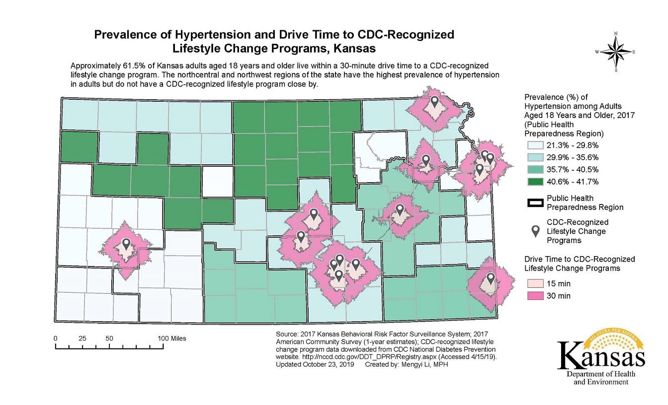
The map allows readers to understand the geographical distribution of the burden of hypertension in Kansas. The map demonstrates the need to expand CDC-recognized lifestyle change programs in the northcentral and northwest regions of the state. These regions have high prevalence rates of hypertension in adults, but do not have a CDC-recognized lifestyle program close by.
ArcGIS
2017 Kansas Behavioral Risk Factor Surveillance System (KS BRFSS). 2017 American Community Survey (1-year estimates). CDC-recognized lifestyle change program location data downloaded from CDC National Diabetes Prevention website. Available at http://nccd.cdc.gov/DDT_DPRP/Registry.aspx. (Accessed 4/15/19).
This choropleth map displays the region-level prevalence of hypertension among adults aged 18 years and older based on the 2017 Kansas BRFSS. Regions were defined as the 16 Public Health Preparedness Regions. The prevalence of hypertension was divided into quartiles. Locations of CDC-recognized lifestyle change programs were retrieved from CDC National Diabetes prevention website on April 15th, 2019. The locations were geocoded using ArcGIS Pro 911 Composite. Only on-site locations of the programs were displayed. Drive time to CDC-recognized lifestyle change programs was calculated using ArcGIS Pro Network Analysis. Fifteen-minute and 30-minute service areas were displayed. Lastly, tract-level population weighted centroids derived from the 2017 American Community Survey were used to estimate the percentage of the Kansas adult population (18 years and older) living within a 30-minute drive time to a CDC-recognized lifestyle change program.
Mengyi Li, MPH, Kansas Department of Health and Environment
Mengyi Li, MPH, Kansas Department of Health and Environment. Accessed from the Centers for Disease Control and Prevention's Chronic Disease Map Gallery.

