Key points
Map

Data sources
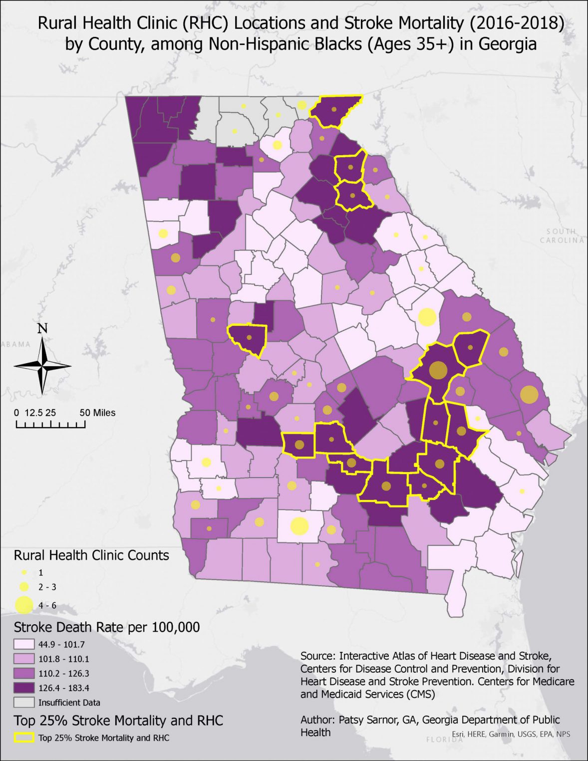
Stroke death rates among non-Hispanic Blacks in Georgia varied by county. 37% of counties in the top 25% of stroke death rates have at least one rural health clinic (14 of 38 counties). This map is impactful because it illustrates that despite the existence of rural health clinics in Georgia’s high burden counties, stroke death rates in those counties remain relatively high. This may inform future health care collaboration as these counties have the heaviest burden and could benefit from interventions. Interventions could include care management, cardiovascular disease risk, prevention, and treatment options, and health education campaigns as preventative measures to reduce stroke death rates in those counties.
ArcGIS Pro
- Stroke Mortality: Interactive Atlas of Heart Disease and Stroke, Centers for Disease Control and Prevention, Division for Heart Disease and Stroke Prevention
- Rural health clinic counts: Centers for Medicare and Medicaid Services (CMS)
Graduated symbols were used to display the counts of rural health clinics in Georgia. 14 counties were identified in the top 25% mortality rate and with rural health clinics.
County FIPS Code
County Name
Rural Health Clinic Counts
13001
Appling
1
13005
Bacon
2
13017
Ben Hill
3
13069
Coffee
2
13081
Crisp
3
13267
Tattnall
1
13315
Wilcox
1
13293
Upson
6
13107
Emanuel
1
13119
Franklin
1
13165
Jenkins
1
13195
Madison
1
13241
Rabun
1
13279
Tooms
1
A definition query was used to identify counties in the top 25% of stroke mortality. Stroke mortality rate is displayed using a 4 -category legend with quartile methodology and graduated colors. Rural health clinic counts are displayed using 3-category legends and graduated symbols. Color editor was used to display stroke death as approved CDC Hex codes when selecting the color scheme.
The stroke death rates were categorized into quartiles. Counties in the highest quartile and with at least one rural health clinic are highlighted in yellow. Stroke death rate was reported as deaths per 100,000.
Coordinate system: NAD 1983 Georgia Statewide Mapping System
World Light Gray Canvas Based was used to outline Georgia on the map.
Georgia Department of Public Health wants to engage to expand its partnership with large rural health clinics/hospitals with a focus on primary care to address hypertension and cardiovascular disease in high burden communities. This map will assist with identifying areas with high stroke death rates that could benefit from a cardiovascular disease intervention (e.g. Healthy Heart Ambassador Blood Pressure Self-Monitoring Program). The CVH team will plan to collaborate with these rural health clinics in counties with high stroke death rates for additional hypertension and cholesterol awareness/prevention work.
Patsy Sarnor, Program Coordinator
Georgia State Department of Health
patsy.sarnor1@dph.ga.gov
Patsy Sarnor, Georgia State Department of Health. Accessed from the Centers for Disease Control and Prevention's Chronic Disease Map Gallery.
