Key points
Data sources
Background: Asthma that is poorly controlled often leads to avoidable hospitalizations and emergency department (ED) visits, high health care cost, absenteeism in school and work, and poor quality of life. The asthma burden for Connecticut residents remains disproportionately high among specific vulnerable communities. Putting on AIRS (POA) program is an asthma home visiting program providing intensive asthma management, education, and environmental support for people with asthma that is poorly controlled.
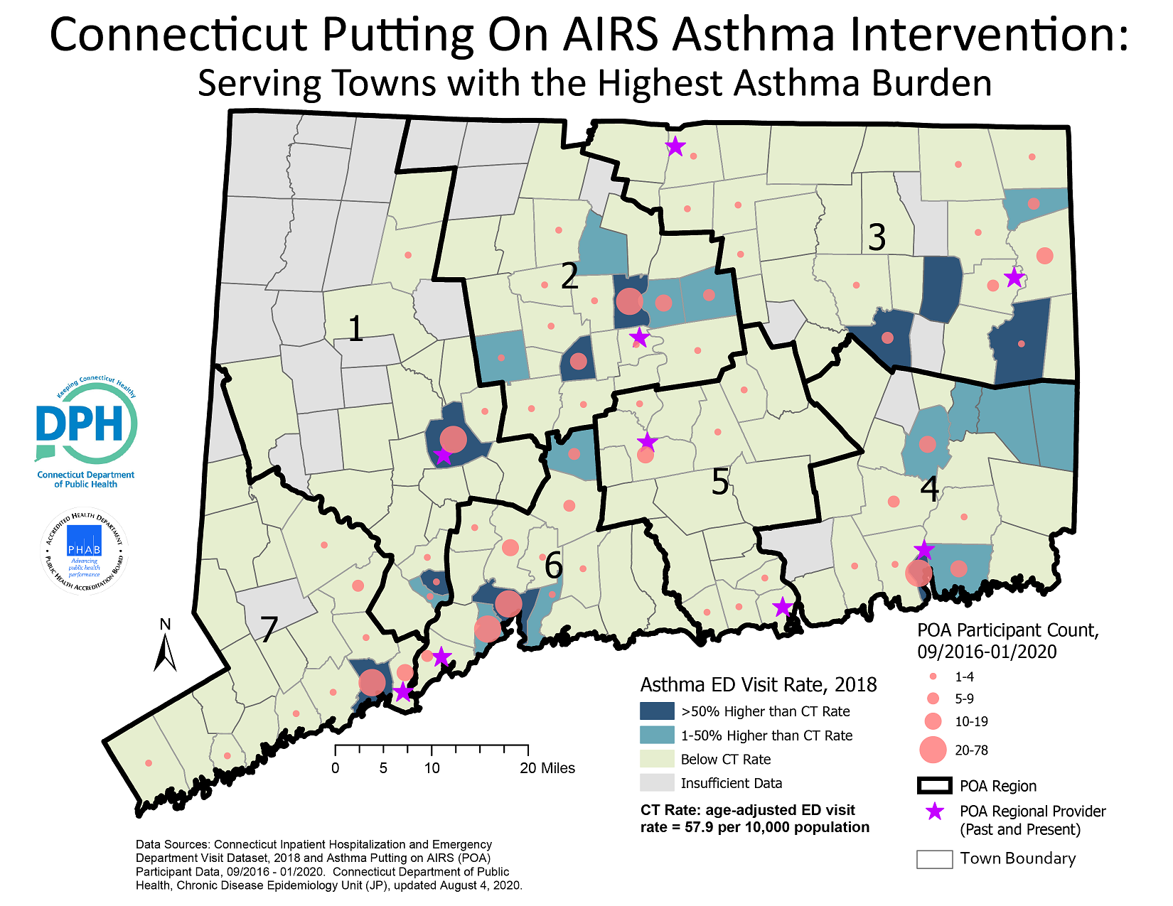
To reduce asthma disparities among Connecticut residents, the Connecticut Asthma Program used a regional approach to align POA activities with towns experiencing higher burden of asthma ED visits. In general the POA program does a good job of providing asthma intervention services in communities with the heaviest burden of asthma emergency department visits; but the map also suggests that there may be some gaps in POA services in rural towns located in the eastern portion of Connecticut.
ArcGIS Pro 2.5.2
Connecticut Inpatient Hospitalization and Emergency Department Visit Dataset, 2018; Connecticut Asthma Putting on AIRS Participant Data, 09/2016 – 01/2020.
Asthma emergency department visit rates for Connecticut statewide and by town were obtained from the Connecticut Department of Public Health Asthma Program website, and the rate for each town was categorized as >50% higher, 1-50% higher or below the Connecticut statewide rate and displayed using Unique Values symbology.
Putting On AIRS (POA) participant and provider data were obtained from the Asthma Program, and their addresses were geocoded using the United States Census geocoder. Geocoded POA participant points were Spatially Joined to the towns using the Intersect Match method to determine number of POA participants for each town, and Graduated Symbols with 15% transparency were used to plot the results. Point Markers were used to display the location of POA providers.
Connecticut shapefile for towns was obtained from the Connecticut Department of Energy and Environmental Protection website. Town shapefile was joined with a table of towns and associated POA region; the result was exported as a feature and POA region boundary was created using the Dissolve data management tool.
To reduce asthma disparities among Connecticut residents, the map can be used by the Connecticut Asthma Program to evaluate if Putting On AIRS activities are appropriately serving people in areas of highest asthma burden. The map can also be used to advocate for additional funding and resources to be allocated to the rural towns located in the eastern portion of Connecticut.
Justin Peng, Supervising Epidemiologist, Connecticut Department of Public Health
Justin.Peng@ct.gov
(860) 509-7774
Peng, Justin, MPH, Connecticut Department of Public Health. Accessed from the Centers for Disease Control and Prevention's Chronic Disease Map Gallery.

